![]() Voluntary citizens' group
Voluntary citizens' group
"I mati dela Sorna" of Brentonico
No address or telephone number
Please refer to the author
(logo by Aldo Ripamonti)
![]() Voluntary citizens' group
Voluntary citizens' group
"I mati dela Sorna" of Brentonico
No address or telephone number
Please refer to the author
(logo by Aldo Ripamonti)
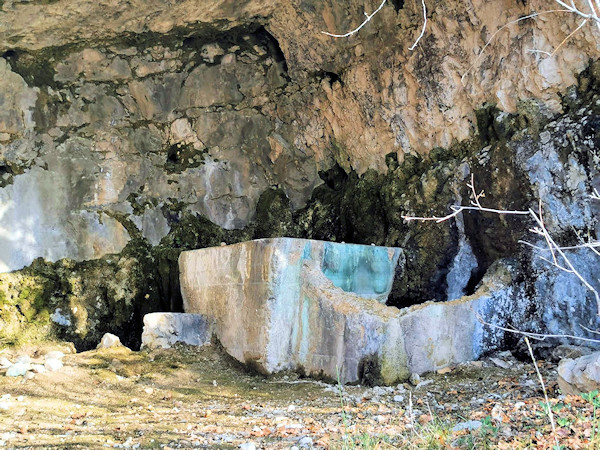
The water collection tank in the cave at the start of the trekking
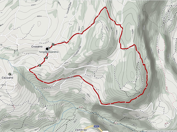
Easy and short route. A little attention is required to visit the war posts. Park at the Crosano cemetery, the only place that is always free. To reach it, climb up to the church and, after passing it, go up the small road that leads to the cemetery for about 150 metres. From the car park, descend on foot to the Circolo di Crosano, where you can enjoy a good cappuccino, then descend further past the bakery until you come to a fountain, follow the road to the left 'alla villa' that leads directly onto the municipal road. Continue downhill along the road that leads to the small church of S. Antonio, where it is also possible to park in the special area in front of the church. Near the church, a small dirt road climbs up to the rock climbing crag of Crosano, walk for about 200 metres until you reach a small road that descends slightly to the right and, past a slab with climbing pitons, you encounter the first relics of the Great War. First a cave in which a basin had been built to collect the little water that gushed from the rock. You follow a wide ledge that allows you to visit the successive emplacements until you reach the sign indicating 'Batteria 4° pezzo'.
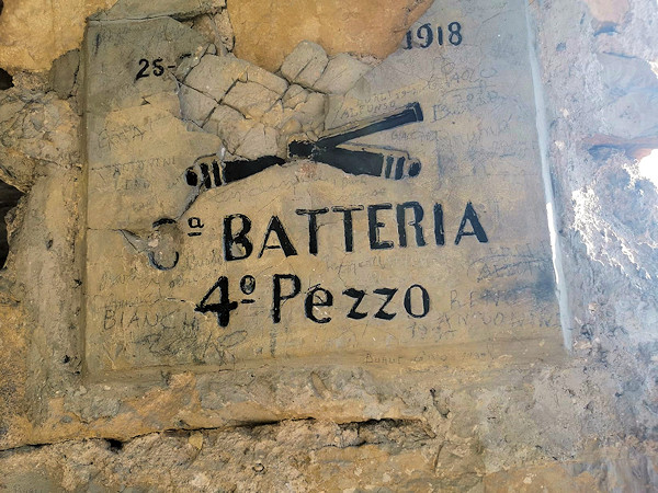
The cannon battery and the regiment sign
Still following the high ledge, you reach an uphill tunnel with a ladder carved into the rock that allows you to reach other stations installed on the rock face. It is not recommended to enter the tunnel because the terrain is steep and prone to landslides. Continue northwards through sparse woodland with a panoramic view of the Adige Valley for about one kilometre until reaching a drystone wall that supports an ascending path to the left. It is advisable not to lose the reference point of the dry stone wall because, proceeding straight ahead you will come to the edge of an overhang in a dangerous area. Continue northwards through the forest until reaching an abandoned farmstead. A small country road runs alongside some vineyards until it reaches the asphalt road near a capital. The Giro della Croce continues to the right on small country roads and, after about 300 metres, a first cross is reached at a crossroads. Climb to the left slightly uphill for another 300 metres. At the crossroads, keep to the left again following the road that shortly leads again to the cemetery car park. If you have stayed within the allotted time for this excursion (3 hours), you can enjoy an aperitif at the Circolo di Crosano bar.
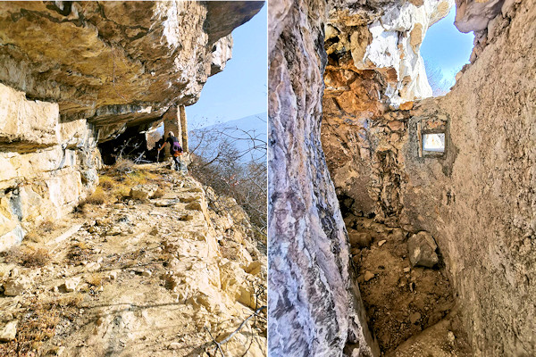
The numerous war posts that can be visited in Crosano di Brentonico
Just a few lines on the history of Brentonico, which give an insight into the vicissitudes of this strange place. It is about the war unleashed by the King of France against the Austro-Hungarian Empire. In 1703, the Duke of Vendome destroyed Saiori Castle while his commander Moange headed towards Brentonico. The French behaved worse than barbarians: they destroyed, robbed and killed anyone in their path. The inhabitants of Brentonico fled to Mounte Altissimo while the Crosani could only find refuge in the impassable area of 'Cronil'. The whole village fled taking women, children and goats with them and found shelter under the 'French Pale'.
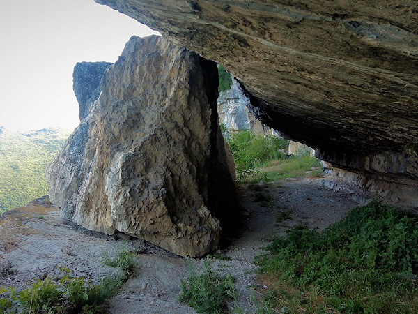
The ledge of the Pale dei francesi
From the locality of Santa Cecilia, near Chizzola, looking westwards, you can see a long ledge covered by huge rock roofs. The place is large and provides shelter for hundreds of people and animals, but reaching it is anything but easy. From the top of the large rock, you have to descend a steep gully, practically climbing, until you reach the ledge, and here is the most difficult passage: a traverse on a narrow rocky ledge, about ten metres long, until you reach the wide horizontal ledge. In 2012, following the initiative 'Adopt a path' launched by the Monte Baldo Nature Park, many inhabitants of Crosano rushed to clean and secure the access path to the Pale dei francesi. Unfortunately, the means and knowledge were scarce and only two slender pieces of steel cord were put in place, which did not allow for full safety.
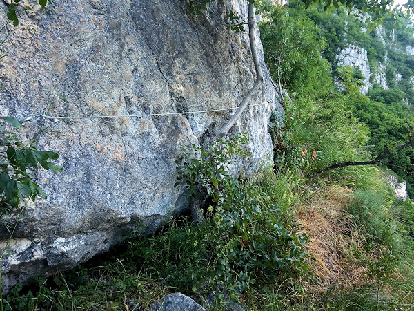
The slender lanyard facilitating the passage over the blades does not provide any security
On this occasion, native parsley plants were found, which were also analysed by CREA. Logic dictates that a plant grown independently on rocky ground would have different quality characteristics and essential oils to parsley grown intensively in the lowlands. The story caused a sensation, the new plant was given the name 'Cronil Parsley' and some people did their utmost to collect the precious plant on site, practically depleting the seeds and plants in the area. A booklet was published on the affair, complete with access map, by Remi Andriollo, and this still increased the visits of 'tourists'. The plants and seeds were the subject of a research by the 'Council for Agricultural Research and Analysis of Agricultural Economics' CREA. The aforementioned authority ruled: 'In conclusion, by its morphological characteristics, which distinguish it from cultivated varieties, and by the content and chemical composition of the essential oil rich in compounds that define its aroma and devoid of others with toxic properties, Cronil Parsley constitutes an interesting local resource, endowed with a special link with the territory and deserving of actions for its enhancement'. A question arises: how did the plant's seeds end up here? Probably a runaway farmer from Crosano had brought them with him and sowed them locally. It follows that plants or seeds taken to a different cultivation context (the home garden) lose their original organoleptic characteristics. Having exhausted the botanical argument, one must remember what one can see at Cronil. There are still holes in the rock, which served to prevent anyone or some animal from falling into the precipice below.
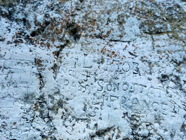
The inscriptions on the rock at the Pale dei Francesi
Also interesting is the inscription engraved in the rock that reads: '1703 in questi paesi sono stati li francesi' ('1703 the French came to these countries') and also carved in the rock is a checker for the 'tria' game. Not to be forgotten is the majestic panorama over the entire Adige Valley, the feeling in this place is to be outside the world and to see life flowing beneath one's feet. Recently, the group of volunteers 'I matti della Sorna' asked the inhabitants of the village of Crosano whether they should not secure the Cronil area to make it safe. The answer was negative, the inhabitants citing the reason that increasing the number of 'tourists' would the parsley plants would disappear completely. In fact, the plants have already disappeared, either because of thievery or because of the long drought of summer 2022. We write these lines for the sole purpose of preventing the story of the French Pale from going into the great oblivion of history.
WARNING - The group of volunteer citizens called 'I mati dela Sorna' has worked hard to make the trek as safe as possible. Keep in mind that Monte Baldo is still a mountain and, as with all excursions in an alpine environment, it is not absolute safety cannot be guaranteed.
MONTE BALDO TUTTI I SENTIERI NEL CANYON SORNA - MAP CANYONTREK SORNA
UNKNOWN PATS ON MONTE BALDO - SENTIERI SCONOSCIUTI SUL MONTE BALDO
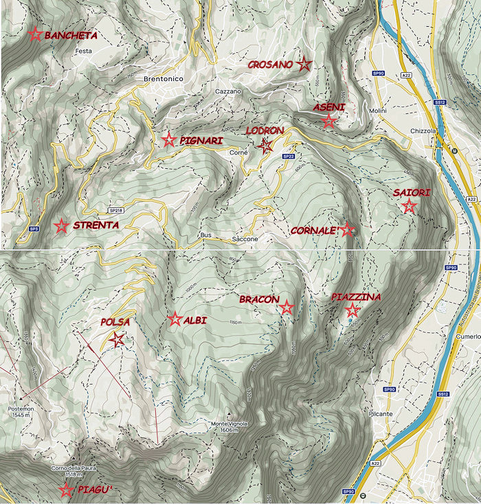
CORNALE' - BANCHETA - PIGNARI - BRACON - ASENI - SAIORI - PIAGU' - PIAZZINA - ALBI - CROSANO - POLSA - LODRON
SOURCES - From outdooractive.com, you can also download the gpx file of the route.
Web site https://out.ac/IJuMBM
Alltrails.com maps - Delio Zenatti's gps tracks on outdooractive.com