![]() Voluntary citizens' group
Voluntary citizens' group
"I mati dela Sorna" of Brentonico
No address or telephone number
Please refer to the author
(logo by Aldo Ripamonti)
![]() Voluntary citizens' group
Voluntary citizens' group
"I mati dela Sorna" of Brentonico
No address or telephone number
Please refer to the author
(logo by Aldo Ripamonti)
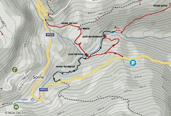
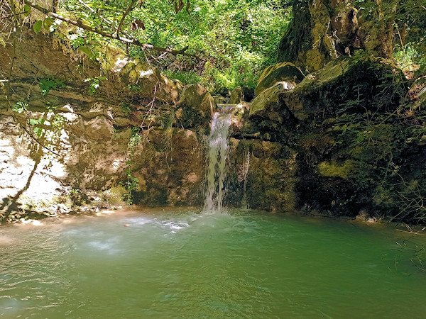
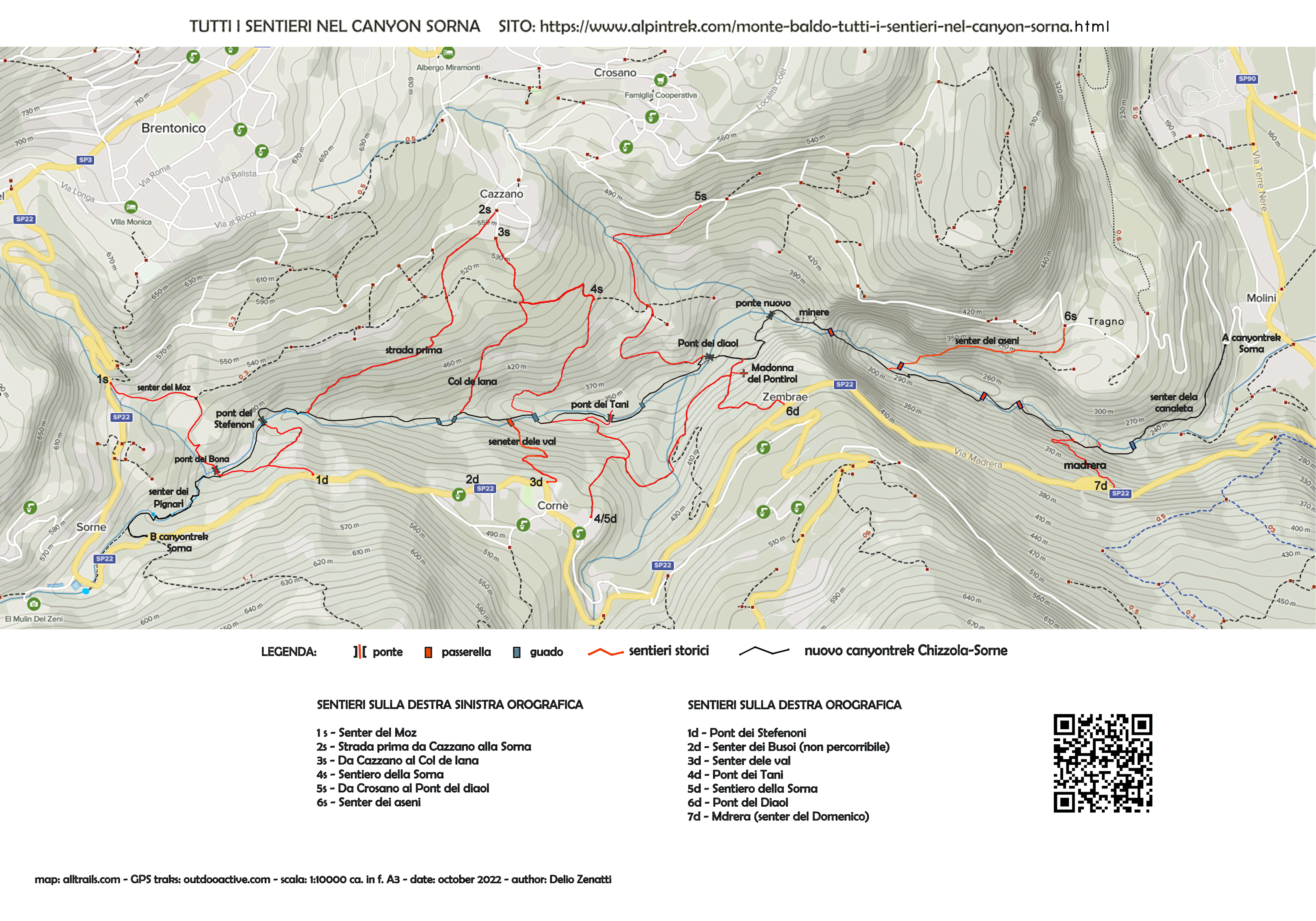
Park on Provincial Road 22, near the starting point, coming from Corne', on the left side of the carriageway. The car park is located near a bench and is small (max. 3 cars), alternatively you can park in Corne' in the large car park in front of the church. car park in front of the church; this involves an additional walk of about 850 metres (10 minutes on foot). You descend an easy dirt road to a crossroads and turn right until you reach Pont dei Stefenoni in about 10 minutes. Here begins the most interesting stretch of the the riverbed of the Sorna torrent. Going to the right, before the bridge, you can visit the remains of the Stefenoni Mill, caution is advised, the walls of the mill are unsafe. After crossing the bridge, you will reach a fantastic place: at first a stream, formed by the overflow of an aqueduct winds its way through a green fairytale environment. Descending to the right, along the stream, you reach the confluence of the two torrents and three distinct waterfalls can be admired. Looking up to the right is a sloping waterfall formed by a thousand rivulets that can be climbed on the tuffaceous rock; to the left, the two imposing and wild waterfalls cascading down the Pont dei Stefenoni. Continue following the valley the torrent until shortly reaching a waterfall between the rocks that impedes passage. The waterfall pours into a characteristic deep pond, called 'boiom' in dialect. Here, some adventurous fishermen used to climb up the rock plate to the left and then descend back into the stream via a wooden pole. Some of us had tried this passage many years ago and concluded that the route was impractical for a normal hiker. As we will explain below, this part of the Sorna canyontrek is the one that took all our inventiveness and work to facilitate the passage and much remains to be done. We strongly recommend returning to Pont dei Stefenoni to finish this adventurous excursion.
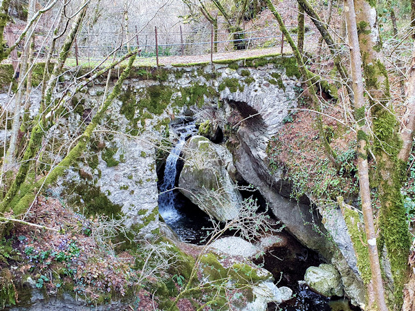
The Pont dei stefenoni connected the two banks of the Sorna to serve the mills
Once past the bridge, a narrow path can be seen to the right that runs alongside the rock, past the passage, continue on easier terrain on a recently marked path (2021) and therefore not very evident until you come in sight of Pont dei Bona. From here start two paths: crossing the bridge, the Senter del Moz begins on the left, continuing straight on following the flow of the Sorna begins the Senter dei Pignari. The route is short (approx. 650 metres), but in an enclosed and rather severe environment, and therefore requires a bit of adventurous spirit and must be tackled with low water flow. At a distance of about 40 metres from the bridge, one can admire the first waterfall formed by the inflow of the torrent Fontechel into the Sorna riverbed, and here the first ford is needed to reach the orographic left. Crossing the torrent is easy walking on the protruding boulders, which can sometimes be slippery (poles are advisable), but it is not dangerous because the water rarely reaches a height of 20 cm. You walk along the orographic left for about 70 metres until you come to a passage on a boulder about 2 metres high; we installed two steel brackets to facilitate the ascent. Once past the rock jump, you can see in the background a small waterfall that seems to impede the passage. Here a second ford is necessary, similar to the first, and going up a short steep slope we reach a path that we follow on the orographic right. When it proves impossible to continue, descend again into the stream bed and cross it, then easily climb up the opposite bank and soon reach a passage between two boulders, facilitated by a small log ladder. An easy ford follows and you continue on the orographic right, after about 100 metres you reach a characteristic sloping slab on which a chain has been installed to facilitate the passage in case of wet ground. You descend a subsequent sloping slab into the stream bed where a jammed boulder allows you to pass on the orographic left. Continue along a short narrow ledge until reaching an easy half-steep path that leads to a small lake fed by a pleasant little waterfall. In hot weather, this is an ideal place to cool down. You cross the stream for the last time and, having ascended the opposite bank on a steep slope, you follow the path with two hairpin bends and then along a level path until you reach the water intake of the power station. From here, a narrow road leads to Provincial Road 22, via which you can return to your car or to the village of Corne'.
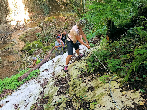
The Pignari senter is no walk in the park. You need some experience on mountain trails
We do not intend to bore you with the entire history of this magnificent canyon, its mills and other mule-tracks existing until the early 1900s, which have already been described in another of our texts. We just want to bring to your attention the historical evolution of some particularities that you can visit during the hike.
Although not part of our hike, it is important to know the reason why this path is no longer passable. In living memory, when today's convenient roads did not yet exist, the Senter del Moz was used by the inhabitants of Corne' to travel to Brentonico. In the post-war period there was a donkey service to transport bread from Brentonico to Corne' and until the 1960s it was used by middle school students to go to school. After the year 2000 the path was little used, a retaining wall had collapsed, the forest had invaded the entire site and many collapsed trees were blocking the way. We worked hard for a few days in two successive times to restore the path and everything seemed to be in order. Problems arose when the owner of an orchard, crossed by the path for the length of about 150 metres, complained of apple theft on his property and installed an inaccessible gate, right at the mouth of the path on the municipal road. Our protests and the complaints of the many walkers were in vain: the historic path, despite being on all maps, it has never been surveyed, it is on private land, and the owner has the legal right to prevent its passage. Pity!
The logical consequence of the closure of the Moz Senter was the problem of finding another way out of the already complicated Canyontrek Chizzola-Brentonico. We searched and tried various solutions for a long time, but the only one that could be proposed was to follow the Sorna torrent riverbed again which presented enormous difficulties but no danger. We worked hard to trace a path even by installing chains and stirrups to facilitate the most difficult passages. The environment is wild and has some unforgettable views with several small waterfalls, enchanting little lakes and even some rocky veins of black basalt. It is strange to find here this type of rock of volcanic origin probably formed on the seabed millions of years ago. Another naturalistic peculiarity found in the area is the presence, at the edges of the waterfalls, of a reddish coloured algae reddish-coloured seaweed (see the Fontechel stream waterfall), no one living in the area has ever seen it and no one can tell us what plant it is.
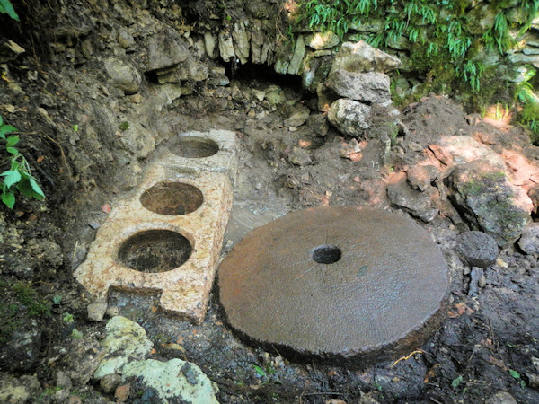
Under the rubble of the Stefenoni mill, we found these historical artefacts
About 50 metres downstream from Pont dei stefenoni, you can visit the remains of the mill of the same name. The mill was still active until the early 1900s and some of us had seen the intact building complete with sheet metal roofs and tiles. There were two roads leading to the mill, one was the current one from Provincial Road 22 and another road crossed the slope of the landslides and went up a mule track, which still exists today, as far as the village of Cazzano. The road also appeared on the maps of the Austro-Hungarian Empire, but subsequently three separate landslides, for a length of about 150 metres, interrupted the important communication artery. The landslides were caused by the change in the hydrogeological balance due to the construction of structures built upstream: the asphalting and concreting of the roads poured downstream huge quantities of rainwater and the of rainwater downstream and the steep slope became unstable. The crossing of the landslides was one of our main worries because, at first, they thwarted the construction of a path relatively safe, from Chizzola to Sorne. We finally found, very high up, the old track, carved into the rock, of the road marked on the maps of the Austro-Hungarian Empire and there we marked out the new path. In the year 2019, we learned that the ruins of the Stefenoni mill concealed important finds. Naturally, we immediately started excavation with the permission of the understanding owner of the site. We found a large millstone and a series of three mortars in which grains were also mills in which grains were also ground, again using water power. The owner declared himself willing to have the finds moved to a place but the weight of the stone parts, about 400 kg each, is beyond our capabilities (a helicopter would be needed). No response from the authorities we have concerned. It is strongly recommended not to remove the metal sheets covering the findings, the perimeter walls of the mill are very unstable and unsafe.
This is the most downstream area of this hike, characterised by a waterfall and the subsequent pool of water that we call by the dialect name 'boiom'. This is where the landslide traverse begins, which must be tackled with a good deal of experience on mountain trails and therefore inadvisable on this type of hike, which is described as easy. The boiom has a special history due to the fact that it was a favourite destination favourite of fishermen and even children in the 1950s. The jump from the platform above the waterhole was a test of courage for the youngsters of the time, given the height of about five metres and the fact that the return involved a path downstream into the stream, naturally barefoot. For the ascent, a pole was used to climb up into the forest and back onto the platform by following an exposed path on the rocks. There are many elderly people in the village of Corne' who still remember learning to swim in the boiom dele frane and assure that no accidents ever occurred. Today, children play in the village's well-equipped park and fortunately there is a different perception of danger and control by the parents. As previously written, the landslide crossing was a long-standing concern of ours. In the end we laid out a new path following the trak of the fishermen, trying to make the crossing as easy as possible.
The Pignari path offers unforgettable naturalistic views
WARNING - The group of volunteer citizens called 'I mati dela Sorna' has worked hard to make the trek as safe as possible. Keep in mind that Monte Baldo is still a mountain and, as with all excursions in an alpine environment, it is not absolute safety cannot be guaranteed.
MONTE BALDO TUTTI I SENTIERI NEL CANYON SORNA - MAP CANYONTREK SORNA
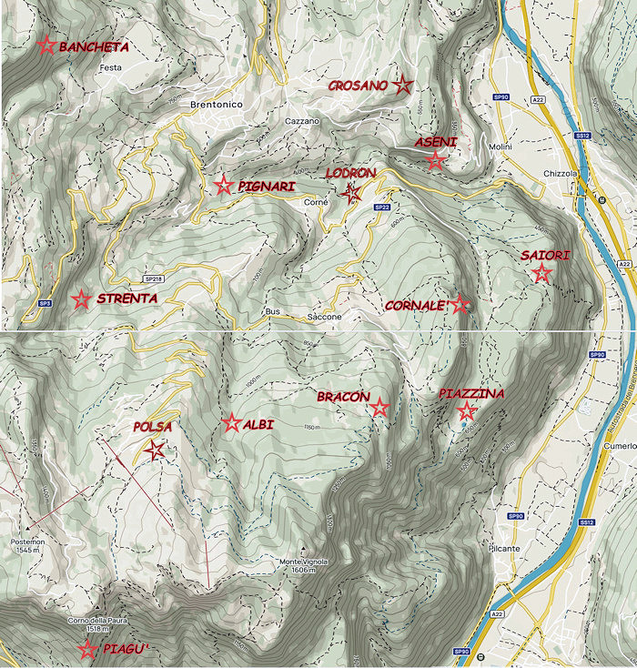
UNKNOWN PATS ON MONTE BALDO - SENTIERI SCONOSCIUTI SUL MONTE BALDO
CORNALE' - BANCHETA - PIGNARI - BRACON - ASENI - SAIORI - PIAGU' - PIAZZINA - ALBI - CROSANO - POLSA - LODRON
SOURCES - From outdooractive.com, you can also download the gpx file of the route.
Web site https://out.ac/IHNtoO
Alltrails.com maps - Delio Zenatti's gps tracks on outdooractive.com